Skip to main content
Private Area
Home
Project
Objectives
Partners
Study areas
Sierra Nevada
Geographical context
Historical context
Archaeological landscape
Historical/current land use
Historical/current water use
Botany
Colli Euganei
Geographical context
Historical context
Archaeological landscape
Historical/current land use
Historical/current water use
Botany
Monti di Trapani
Geographical context
Historical context
Archaeological landscape
Historical/current land use
Historical/current water use
Botany
Vjosa Valley
Geographical context
Historical context
Archaeological landscape
Historical/current land use
Historical/current water use
Botany
MEMOLA Network
Activities
Research
Archaeology
Hydrology
Agronomy
Botany
Ethnography
Pedology
Outreach
Education
Conferences
Seminars and workshops
Exibitions
3D models
Documentaries
Socio-economic
Local development
Cultural thematic routes
Policies
Places
Cáñar
Lanteira
Lugros
Blog
Events
Resources
Routes
Contact
Links
Enter your keywords
M. Toscano
You are here
Home
/ M. Toscano
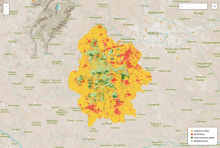
Naturalness map, with four categories: Agricultural, High Naturalness, Seminatural and Artificial.
Study area:
Colli Euganei
Category:
Geodata
Research theme:
Environment
Pages
« first
‹ previous
1
2
3
4